
Trace a Campbell Street by Address
Street-by-street research in Campbell starts with a situs address, not a name. The aim is to separate what a parcel record confirms from what a household clue merely suggests. An APN, or assessor's parcel number, joins the county property layer to a deed. A permit can add project contacts. A voter-status result is limited to the person who submits it. A reverse directory may show a listed subscriber for one year. The working chain is address to Assessor to APN and latest title document to recorder deed to grantor, grantee, and legal description to permitted voter data to a criss-cross directory. Each handoff needs its own check.
- Normalize the street number, direction, street name, type, unit, and city. Use the situs address, not the tax mailing address, because the Assessor warns against entering a mailing address.
- Run the address in the Santa Clara County Assessor search and capture the APN and latest title-changing document number or link. If the structured form is better, use its separate fields and accept the terms.
- Open the county parcel dataset, zoom to the target, and click adjoining polygons or use map and table selection to collect APNs. Treat the geometry as dynamic orientation, not a survey.
- Take the APN and latest document number to the recorder office. Read the grantor, grantee, recording data, and legal description, then search the seller as an earlier grantee when tracing the chain.
- Use the California voter-status tool only for an approved self lookup or lawful file request, then consult a library reverse or criss-cross directory by street and year. Mark every result as owner, registered voter, or listed subscriber.
Campbell's Address Records by Street
A Campbell address guide works best as a set of linked record types, not as one master roll. The APN is the main bridge. It connects the assessor's current parcel facts to the county map and helps the recorder locate a document, while a city permit file adds a separate address history. Voter information and reverse directories answer different questions about people, so the table keeps ownership, geography, project activity, and historical listing evidence apart.
| Record set | Keeper | What it can show | Access |
|---|---|---|---|
| Assessment parcel | Santa Clara County Assessor | Situs, APN, assessment facts, and a latest-document bridge | Free address or APN search; terms apply |
| Parcel GIS | County Open Data | Geometry, adjoining APNs, and map attributes | Free map, summary table, pan, click, and export |
| Recorded deeds and liens | Santa Clara County Clerk-Recorder | Grantor, grantee, legal description, dates, and prior owners | Office research; copies by counter, email, or mail |
| Voter status or file | California Secretary of State and County Registrar | Self status or fields released for a permitted purpose | Identity-gated self lookup or approved request |
| Building and planning records | Campbell Community Development | Address, scope, dates, and public project parties where releasable | Address interface, MGO, phone, email, or focused request |
| Reverse or criss-cross directory | Library and catalog custodians | Listed occupant or subscriber by street and year | Catalog, library reference help, and year-specific access |
The sets chain in a deliberate order. Parcel number ties the roll to GIS and the recorder. A deed's legal description tests whether the same land persisted through a subdivision. A permit date can explain a new unit or changed number. A voter record is not a substitute for those steps, and a reverse listing is a dated snapshot rather than proof of current presence.
Use the Campbell Street Search Form
The Santa Clara County Assessor Real Property Search has three paths: Simple Address, Advanced Address, and Search by APN. Advanced Address is the useful mode for address-by-address work because it separates the number, direction, street name, suffix, unit, and city. Select Campbell where the parcel is returned as Campbell. There is no public owner-name or all-residents mode, and the search is for real property rather than a household roster. The terms checkbox must be accepted before a result appears.
| Field or control | How it helps | Limit to keep in mind |
|---|---|---|
| Simple Address | Searches a complete situs address. | Do not enter the assessment mailing address. |
| Street Number | Starts the structured address. | Use the number assigned to the parcel. |
| Street Direction | Separates directional parts such as N or W. | Leave blank when none applies. |
| Street Name | Holds the name without its suffix. | Try a historic spelling when records vary. |
| Street Type | Chooses a suffix such as Ave, St, or Blvd. | It is a separate control from the name. |
| Unit | Adds a condominium or unit identifier. | A unit search is still parcel research, not a people list. |
| City | Filters the advanced search to Campbell when available. | Postal city and incorporated city can differ. |
| Search by APN | Reopens a known parcel record. | County format is eight digits, often shown as 123-45-678. |
| Terms checkbox | Confirms acceptance before the search runs. | Required for the public portal. |
The Santa Clara County Assessor search is the source for the address and APN screen used to begin a Campbell address search.
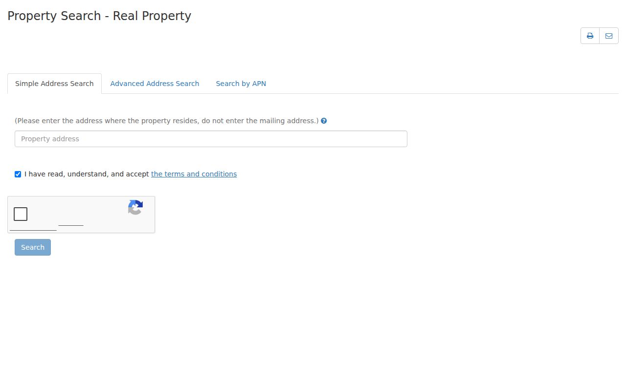
The result supplies parcel facts and the bridge toward a title-changing document. It does not certify who lives at the situs or expose a public owner-name browse. If an allowed county channel or counter record is needed for ownership, use the custodian's process rather than a third-party copy.
Note: An owner name found through a permitted county channel still does not establish who sleeps at the address.
Campbell Street Parcels in GIS
The Santa Clara County parcel map and dataset supports a map view, a summary-table view, pan and zoom, feature clicks, and export. Find the target by address or APN, zoom until parcel polygons are clear, then select each lot touching the same block. Record the APN and situs shown for each selected shape before opening the Assessor record. This is a practical way to walk a street without pretending the map is a complete directory.
County data are dynamic and supplied as-is. Parcel lines are for orientation, not a boundary survey. The public layer should not be treated as a promise of an owner name or tax mailing address. When a shape, situs, or APN looks wrong, compare the returned parcel with the county's primary record, a recorded legal description, or a survey held by the proper custodian. The map can expose an adjacent parcel that a single-address search would miss, but it cannot decide whether a person occupies it.
- Parcel
- A mapped unit of land identified by an APN and tied to assessment records.
- Situs address
- The physical location of the parcel, distinct from the address used for tax mail.
- Plat
- A recorded map or subdivision plan that helps compare land descriptions and lot layout.
- Criss-cross directory
- A reverse directory arranged by street address, often listing an occupant or telephone subscriber for a year.
The process is simple: target address, parcel polygon, adjacent APNs, Assessor check, then recorder research. Each step narrows the next request.
From Campbell APN to Deed
Santa Clara County real-estate records run from 1850 forward, but the public online Official Record Index was removed on November 5, 2018. Street address is not a recorder index field. The bridge is the Assessor's APN and latest title-changing document number. At the Santa Clara County Clerk-Recorder Official Records office, use a public workstation for 1981-present or the Digital Reel and book systems for 1850-1980. Search keys include document number, date, class, APN, grantor, grantee, or a combined party search.
Read the document for the grantor, the person transferring an interest, and the grantee, the person receiving it. Copy the recording data and legal description. Then search the seller as an earlier grantee in a prior time span. The recorder does not perform a title search for a requester, so exact names, initials, trust names, spouse variants, and the year range matter. A pre-May 1, 1995 document may use book and page as the operative locator. The county's deed-chain instructions describe this address-to-document method.
There are several ways to obtain a copy. Counter kiosks allow viewing and purchase. Email bus-rdc@rec.sccgov.org sends a physical copy by mail, and mail requests go to Clerk-Recorder, ATTN Business Division, 110 W. Tasman Drive, First Floor, San Jose, CA 95134. Give the instrument number or book and page, requester name and mailing address, and any useful party, title, type, or date detail. Plain copies cost $4 for the first page and $2 for each additional page; certification adds $2 per document. Posted processing can take up to seven business days. Official records are not emailed.
Campbell Permits by Street Address
Campbell Community Development supplies a second address-keyed trail. The Campbell zoning and land-use page points to records by property address and planning assistance. Building is at 70 N. First Street; building@campbellca.gov and 408-866-2130 are the published contacts. Planning uses planning@campbellca.gov and 408-866-2140. A permit or planning file may show a project scope, date, applicant, contractor, owner, or agent when that information is public. It is evidence of a project, not a resident roster.
New building applications have used MyGovernmentOnline, or MGO, since May 4, 2020. A user account is required to submit a new application. For an older Campbell address, ask Building for a legacy scan or microfiche by exact address and permit type. The city's permit map helps locate activity, while the file or department contact is the place to verify a result. Focused requests should name the address, department, record type, and date range because the city need not create a new record to answer a broad question.
The named plan areas, Downtown, Winchester Boulevard, San Tomas, Campbell Village, and East Campbell Avenue, can explain why a permit sits in a particular planning context. They do not identify private membership or prove that a person lives near a project. Code complaints also need care: an allegation, a code action, and a final finding are not interchangeable.
The city's building application guides preserve the MGO and addressing context for current requests.
Campbell Street Lines and Number Changes
Postal geography can mislead a Campbell address search. ZIP 95008 is broader than the incorporated city, while ZIP 95009 is used for Campbell PO boxes and is not a residential parcel zone. Verify a particular address through USPS ZIP Code Lookup, then verify jurisdiction in county parcel GIS and city property records. A ZIP alone should not choose a permit, tax, school, or public-safety custodian.
Campbell incorporated in 1952. San Tomas is an annexation trap: much of the southwest area developed in the 1940s and 1950s but was incorporated only in the 1980s, so older permits or address references may route to the county even when a current parcel sits in Campbell. Earlier land may also appear under county, township, rural-route, or San Jose-area headings. That is a records-geography issue, not proof that the property had no history.
Campbell's Building Division reviews addressing requests under Municipal Code chapter 18.36. An applicant may propose a street name or number, but Building makes the final approval. Compare the APN, subdivision or plat, and legal description when a number has changed. Street text alone can hide a split lot, a new unit, or an old rural description.
A Campbell Street in Reverse Directories
A reverse or criss-cross directory turns the street into the search key. It may list a number in sequence, a named street, and an occupant or telephone subscriber for a particular year. The listing is useful for a past household, a street spelling, or a clue to when a name appeared. It is not an authoritative full Campbell run, and a missing entry does not prove that no one lived at the address.
Use the Santa Clara County Library District genealogy resources and the Campbell Library reference desk to identify an exact title, edition, year, and location. The Campbell Library at 77 Harrison Avenue has local reference resources and a catalog that should be checked before travel. Library card or in-library authentication may apply. Read the volume's own abbreviation page: entries can use a surname and initial, a spouse in parentheses, an address mark such as h, or a room or residence mark such as r. Do not transfer a key from one publisher to another.
Compare adjacent years. Test street-number variants, directionals, abbreviations, and boundary labels. A reverse listing can be paired with a deed or permit, but it should remain labeled as a dated directory observation. The broader Campbell city directory collection trail is the better place to study historical volumes themselves.
Campbell's Online and Office Split
One of Campbell's most useful research contrasts is the gap between an easy address search and a difficult name search. The Assessor portal is structured for a situs address or APN. The recorder's research is structured around a document, a party, an APN, or a year at the office. The two systems complement each other, but neither creates a complete street roster.
| Source | Best question | Where it stops |
|---|---|---|
| Assessor online search | Which parcel and APN match this Campbell situs? | No public owner-name or all-residents browse. |
| Recorder office research | Which deed parties and legal descriptions connect the parcel over time? | No street-address index and no title search performed for the requester. |
| County parcel GIS | Which lots touch the target? | Dynamic orientation only, not a survey or household list. |
Use the online result to prepare a focused office visit. That small distinction saves a failed name search and keeps the address guide tied to records that actually use the address or APN as a key.
Campbell's One-Hour Recorder Visit
Arrive early at 110 W. Tasman Drive, First Floor, San Jose. Official-record research services are generally available Monday through Friday from 8:00 a.m. to 4:30 p.m., and the county warns that busy workstations can be limited to one hour. Bring current identification for book or microfiche work. Have the APN, latest document number, likely grantor or grantee, spelling variants, and a clear date range ready before taking a seat.
Use the workstation to inspect the document trail, then decide whether a plain or certified copy is needed. If travel is not practical, the counter, email, and mail channels remain available when a document number or book and page can be supplied. A request that begins with only a street name is too broad because the recorder's index does not use street address.
Note: Arrive early because the recorder says busy workstations may be limited to one hour during peak visits.
Limits of a Campbell Street Directory
No Campbell address method can show every person connected with a parcel. Ownership records identify an interest in land, not the full household. People who do not own the parcel, unlisted adults, children, and people using protected addresses may be absent. Driver-record information and utility customer data are not open street lists. California voter information is purpose-restricted, and Safe at Home can provide a substitute mailing address for qualifying protected people. A reverse directory is also incomplete because it depends on listing and subscription practices.
Mailing address, situs address, and legal description must stay separate. A tax notice can go somewhere other than the parcel. A deed can describe land without naming an occupant. A voter status tool is a self-service check, not a public by-street browse. These limits are not reasons to fill gaps with guesses. They are reasons to label each result by source, date, and kind of evidence.
Lawful use. Campbell street and address records support personal, lawful research. California Penal Code section 646.9 and Code of Civil Procedure section 527.6 address stalking and harassment; never use records to stalk, harass, intimidate, or harm anyone.